Which Tube stations are the poshest, by supermarket?
Green Park, which scores 99.9 out of 100 on a supermarket snobbery index: an M&S a few metres from the station, and no Lidl or Aldi for nearly 2 km. East Ham is the opposite, at 1.6: a Lidl or Aldi 64 metres away and the nearest Waitrose or M&S almost 4 km off. Northwood, Marylebone and Richmond are next at the top; Dagenham Heathway and Upton Park at the bottom.
Source: OpenStreetMap (shops, September 2026) and TfL Unified API (stations).
What stands out
- 198 of the 299 stations score over 50, so for about two in three a Waitrose or M&S is nearer than a Lidl or Aldi.
- Waterloo and Victoria both score 96.0, and Canary Wharf 94.7.
- Brixton scores 88.7; Wimbledon, 46.1, has a Lidl or Aldi nearer.
- Only 11 stations score 10 or under.
The numbers
| Rank | Station | Snobbery index, out of 100 |
|---|---|---|
| 1 | Green Park | 99.9 |
| 2 | Northwood | 98.8 |
| 3 | Marylebone | 98.5 |
| 4 | Richmond | 98.4 |
| 5 | Shenfield | 98.2 |
| 6 | High Street Kensington | 98.0 |
| 7 | Ealing Broadway | 97.5 |
| 7 | Rickmansworth | 97.5 |
| 9 | Bond Street | 97.4 |
| 10 | Cannon Street | 96.9 |
| … | ||
| 14 | Waterloo | 96.0 |
| 14 | Victoria | 96.0 |
| 23 | Canary Wharf | 94.7 |
| 53 | Brixton | 88.7 |
| 82 | Oxford Circus | 80.1 |
| 157 | Stratford | 57.6 |
| 216 | Wimbledon | 46.1 |
| … | ||
| 290 | Barking | 8.8 |
| 291 | Canning Town | 8.2 |
| 292 | Morden | 7.1 |
| 293 | Forest Gate | 5.5 |
| 294 | Kingsbury | 5.3 |
| 295 | Tottenham Hale | 3.6 |
| 296 | Alperton | 3.5 |
| 297 | Upton Park | 2.7 |
| 298 | Dagenham Heathway | 1.8 |
| 299 | East Ham | 1.6 |
The top 10 and bottom 10 of 299, with others for comparison.
Download the chart as an image
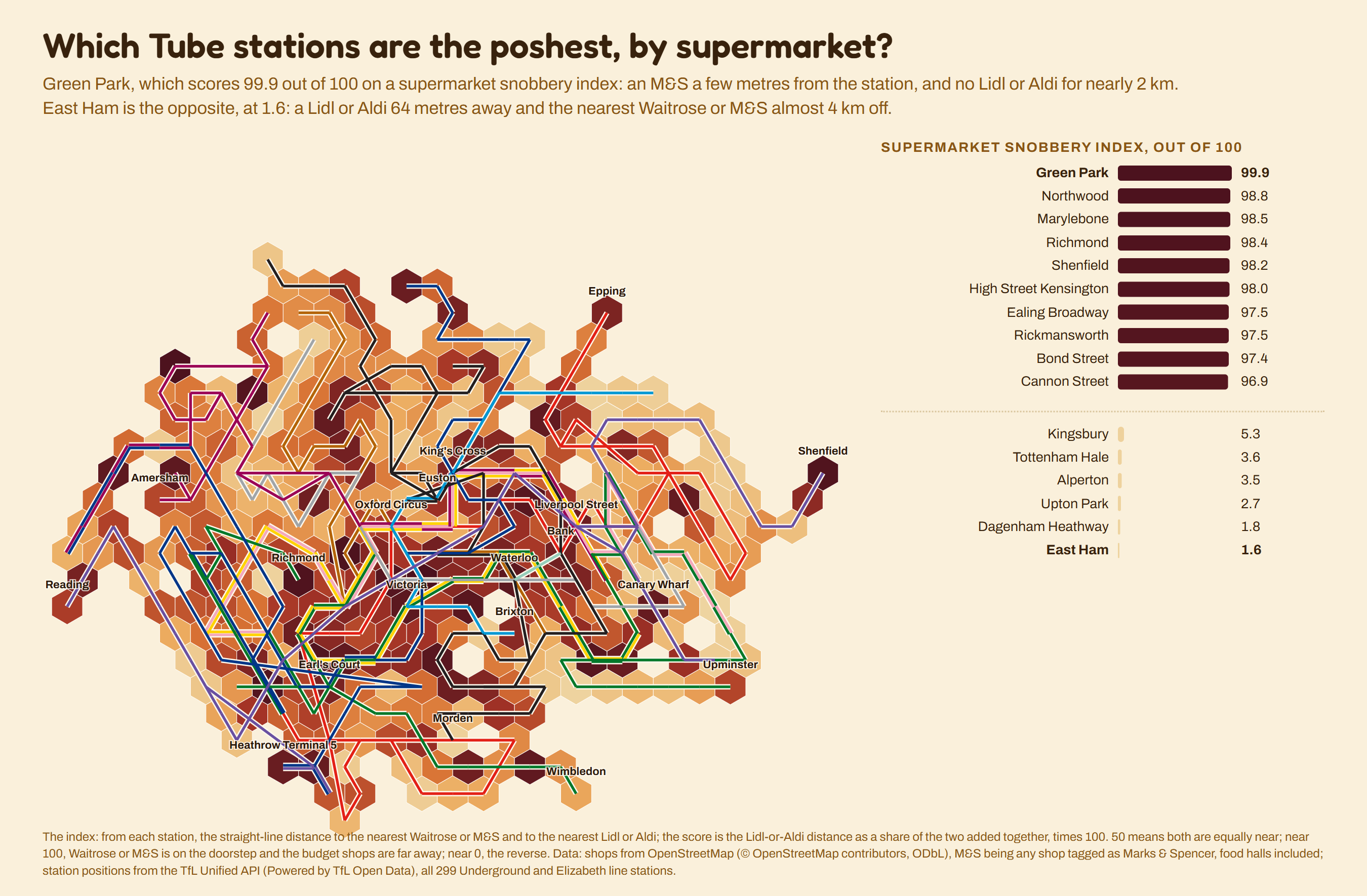
The index: from each station, the straight-line distance to the nearest Waitrose or M&S and to the nearest Lidl or Aldi; the score is the Lidl-or-Aldi distance as a share of the two added together, times 100. 50 means both are equally near; near 100, Waitrose or M&S is on the doorstep and the budget shops are far away; near 0, the reverse. Data: shops from OpenStreetMap (© OpenStreetMap contributors, ODbL), M&S being any shop tagged as Marks & Spencer, food halls included; station positions from the TfL Unified API (Powered by TfL Open Data), all 299 Underground and Elizabeth line stations. Played in Tube Imposter; more maps like it in the Tube explorer.